

The “mountain tsunami” that occurred in the Nepal Himalayas on August 26, 2026, constituted a quintessential large-scale debris flow, initiated by a rock-ice avalanche. The underlying physical processes are fundamentally analogous to those of oceanic tsunamis. Following the collapse of glaciers and bedrock from an elevation of 5,200 m, the ensuing massive debris flow propagated approximately 22 km horizontally, reaching a border checkpoint (elevation 1,800 m) within 6 to 7 minutes of the initial failure. The velocity of the flow in the vicinity of the border was estimated to have attained 180 km/h. Furthermore, the barrier lake formed near the border is of limited volume, suggesting a sufficient temporal margin before any potential catastrophic breach.
This landslide, situated in the Great Himalayas as opposed to the Lesser Himalayas, represents a physical phenomenon fundamentally identical to the 2011 Tohoku megatsunami in Japan. While the Tohoku event manifested as an oceanic tsunami, it was similarly precipitated by the catastrophic failure and collapse of fractured bedrock exhibiting gravitational instability. This mechanism constitutes an alternative etiology for large-scale tsunamis that remains largely unreported in general media.
A critical point of inquiry is why this event manifested as a high-temperature megaflood rather than a snow-driven phenomenon. The primary cause can be attributed to an Omega-shaped (Ω-type) pronounced meandering of the prevailing westerlies, which facilitated the advection of subtropical air masses into the Himalayan region.
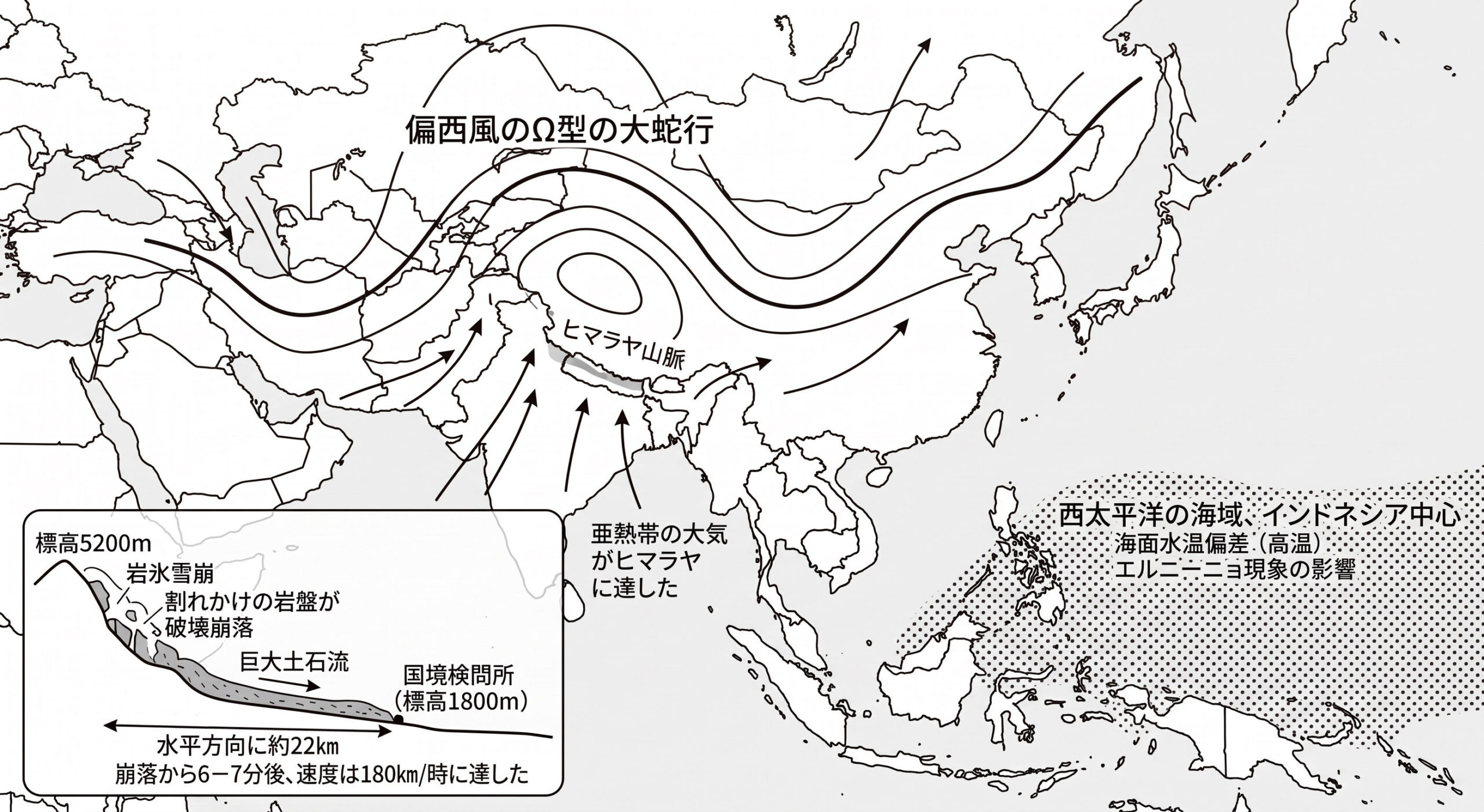
*Note: This figure is a schematic representation and does not strictly depict the exact topography or spatial distribution.
A comparable macroscopic meandering of the westerlies was observed 20 to 30 years ago, encompassing the Japanese archipelago and subjecting northeastern Japan to intense linear precipitation systems. This historical event resulted in severe flooding and levee failures, exacerbated by the parallel alignment of the precipitation systems with the longitudinal axis of the archipelago. Such significant meandering of the westerlies is primarily driven by the El Niño phenomenon, characterized by the anomalous warming of sea surface temperatures in the western Pacific (centered around Indonesia), which consequently elevates regional atmospheric temperatures.
The meandering westerlies generate a northward-convex high-temperature ridge over Southeast Asia. This pattern is coupled with a similar Ω-shaped blocking pattern further west over western Europe (both inducing extreme heat waves, such as those observed in the Paris Basin), while a southward-extending low-temperature trough forms in the intermediate region, resulting in anomalously cold summers. Ultimately, it is imperative to note that the global mean temperature exhibits no fundamental change under these specific atmospheric conditions, and global sea levels have remained relatively stable over the past century, with geostationary satellite data indicating a marginal rise of approximately 20 cm. Regardless, following the dissipation of the El Niño conditions and the subsequent migration of the warm water mass toward the coast of Peru in South America, typical climatic conditions are restored.